This week I saw a news article in the Costa Rica Star that caught my attention.
“Google announced the arrival of its Special Collections to Costa Rica. This option is part of Google Maps, collects 360-degree sights of geographic, touristic, historical or cultural sites throughout the country. In total 76 locations are part of Google’s Special Collections in Costa Rica.”
At first I was confused because the article does not link to any particular source for more information and simply says:
“To access the Google Collections all you have to do is go to maps.google.com, search for the place you are looking for and on the bottom the 360-degree option will display if available.”
The problem is that I found MANY places in Costa Rica that provide you with a 360-degree view of that place, and I couldn’t find any more information on ‘special collections’ related to Google Maps and Costa Rica.
In digging in deeper, I got some answers, and at the same time, opened my awareness to the whole world of Google Street View I didn’t really know existed!
Costa Rica Special Collection Gallery in Google Street View
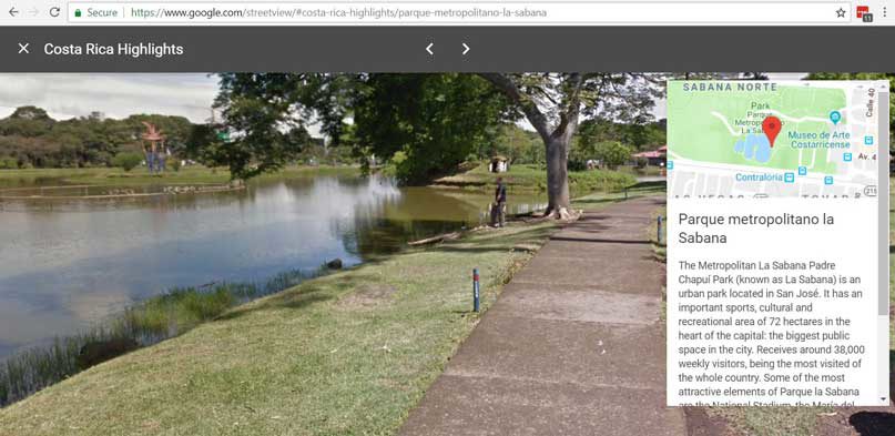
But first, before getting to my interesting general findings on Google Street View, I did want to share more about the Street View Gallery collection for Costa Rica, because it is really impressive.
The direct link to the gallery is here, but currently if you go to the Street View home page, the galleries are the default page, and the Costa Rica gallery is the first one listed, called Costa Rica Highlights.
When you click in, there are 40 different places available, each represented by a small image. When you click on a particular photo, it opens up with a rotating 360-degree view of the site, and then operates like a typical Street View in that you can click the white arrows in certain directions to ‘walk around’.
Many outdoor scenic sites are of course represented, but there are also interesting indoor places and museums such as the National Gallery in San Jose, the National Stadium which you can virtually walk into, and also the main airport in Costa Rica, Juan Santamaria International Airport.
Discovering Isla del Coco
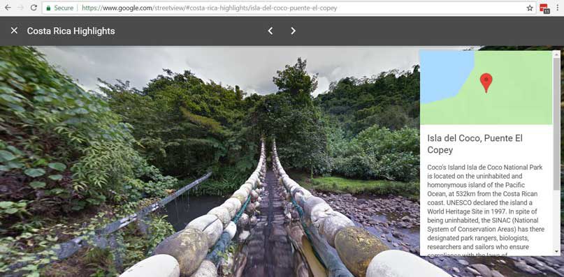
This is a great tool for discovery, and I’m sure Caroline and I will come back and review this gallery as we try to decide what places we want to visit when we visit Costa Rica. The most interesting discovery I made in this first look is Isla del Coco, a place I had not heard of before. There are 4 vistas of Isla del Coco highlighted in the gallery, and the island looks to be truly beautiful and breathtaking. I clicked through to Google Maps to find out where it is located, and was shocked to find it is in the middle of nowhere in the Pacific Ocean!
A quick perusal of the Cocos Island Wikipedia page gave me a quick run down of its history and current usage. Located 342 miles off the coast of Costa Rica, it has a rumored history of use by pirate ships as there are several legends of buried treasure! Today it is a wildlife sanctuary, and the only people who can spend the night are the park rangers. All others must get permission to visit, so your only option to go is to find a tour. Scuba tours are apparently most common.
When it comes to this island, the first thought I had, since Caroline and I just saw the latest Jurassic World movie yesterday, is that this is the island from Jurassic Park, Isla Nublar!
In the movie, it is stated that the island is 120 miles off the Pacific coast of Costa Rica, and while Cocos Island is further away from the coast, according to Wikipedia, there is speculation that Cocos Island was the model for the island in Jurassic Park.
“There has been speculation that Michael Crichton loosely based Isla Nublar on Isla del Coco or Cocos Island in the eastern Pacific.[21][22] Cocos Island is a Costa Rican National Park 340 miles off the west coast of Costa Rica. Like Isla Nublar, which means “Clouded Island”, Cocos Island receives especially high rainfall year-round and is the only island in the eastern Pacific that features cloud forests.[23][24] The physical geography is also similar to Nublar, in that the island is guarded by high cliffs, rugged terrain, and dense tropical vegetation. It is much smaller than Isla Nublar, however, coming in at just over 9 square miles.”
This Bustle article also goes deeper into the explanation.
Street view in Tamarindo and beyond
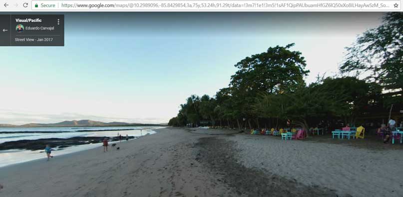
Going back to general thoughts on Google Street View, for our first trip to Costa Rica in early 2017, wanting to get a preview of where we would be visiting, I was a bit frustrated and surprised that Google Street View was not really available for Costa Rica. I just assumed at that point that Google Street View was everywhere!
In lieu of actual Street View at the time, there were just a few stand-alone photos available in Google Maps and so the best I could do was see a basic view of the street corner up to where our hotel was, and a couple of other points around town, but that was about it. The photos were nice because they were in Street View style in that you could pan around and up/down, but any particular photo was just stationary, and limited to a specific spot.
But now when I look at Google Maps and click on the ‘little person’ in the lower right corner to go into Street View mode, I see there are many thousands of Street View photos in the Costa Rica map. Some of them are stationary 360-degree view photos, but some are of the typical Street View variety, where you can virtually walk along the street. Those are not taken by Google themselves, but have been uploaded by individuals, so they operate slightly differently.
(As an aside, did you know that the little man in Google Maps that triggers the Street View is called Pegman? And, did you further know that you can click and drag him around the map? I didn’t, until I watched this great video that explains how to use Street View.)
In Tamarindo specifically, I found a nice ‘walkable’ street view of the central part of town, as well as one of the beach!
Make your own 360-degree street view photos
The big takeaway for me is that it seems like anyone with the right equipment can take a 360-degree photo and upload it to Street View. This same technology is commonly used by restaurants and hotels to show people full 360-degree views of their interior.
I’m not familiar with the kind of camera you need, but the Street View website has all kinds of resources on what equipment to use and how to do it.
I think we need to figure out how to do this ourselves so we can post these kinds of 360-degree virtual photos of our AirBNB vacation rentals!
Google Street View App
The last thing I learned is that Google has a Street View app for iPhone and Android so that you can very easily take Street View on the go.
In areas that have standard Google Street View mapped by Google itself, it is really simple to navigate that particular area. In the Explore tab, you see red dots indicating the available streets, and clicking on one will take you into the street view of that spot. Then the paths through the street are indicated by a blue line. Simply swiping up or down on that blue line virtually drives you up or down that particular street.
The featured tab will show you galleries such as the Costa Rica Highlights described above. In the map, you will have to zoom out and eventually you’ll see red dots that indicate one of these featured spots. When you click in you’ll see the 360-degree view and then can click on the white directional arrows to move around.
In places like Costa Rica / Tamarindo where many people have simply uploaded their own custom 360-degree photo, Street View can be very overwhelming, but at the same time it can be useful and fun to simply browse a place by looking at all the posted photos.
Download the app from the App Store or the Google Play Store!
 We are Scott and Caroline, 50-somethings who spent the first 20+ years of our adult lives in New York City, working traditional careers and raising 2 kids. We left full-time work in our mid-40’s for location-independent, part-time consulting projects and real estate investing, in order to create a more flexible and travel-centric lifestyle.
  Financial independence and early retirement is not something we originally focused on, but over time realized it was possible. Our free report,