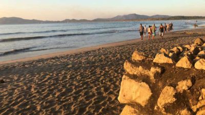
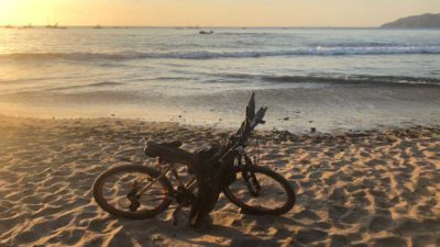
In my view, low tide is the best time to spend at the beach in Tamarindo. The waves break pretty far out, which leaves lots of room to enjoy relatively calm water closer to shore, and provides plenty of sand for walking around and collecting seashells. It also exposes many large rocks, as seen above, which are completely hidden at high tide.
The beach at Tamarindo is always spectacular. Even though it can be very crowded by Costa Rican standards, it is far less crowded than the beaches I’m used to visiting in the USA. In the lower seasons, the beach at Tamarindo is even less crowded and great to enjoy.
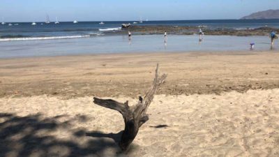
The thing that strikes me most about the beach in Tamarindo is the difference in the tide line between the high tide and the low tide. On the center part of the beach in Tamarindo, at high tide there is very little room on the sand to move around, with the tide line almost coming up to the top of the beach. The Langosta side also gets pretty tight, although as you go north towards the estuary, it is not so much of a problem as the beach is wide, but still, there is still a huge difference between high and low tide.
-
- At this spot, high tide almost fills the beach
-
- Same spot, looks completely different!
On our trip last week, low tide was generally in the middle of the day, the hottest part of the day, when we chose not to go to the beach, so I have no photos from low tide, but I do have some medium tide photos as well as high tide photos to show the comparison. The differences are stark.
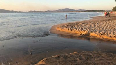
-
- High Tide at the center of the beach shows some space for walking.
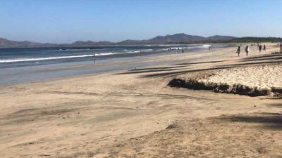
-
- Alternatively, there is tons of space when the tide is lower.
I understand that my enjoyment of the beach will almost certainly be different than your enjoyment of the beach. For me, I enjoy walking the beach in the morning, walking the beach at sunset, and perhaps occasionally swim and sun in the middle of the day. On the trip Caroline and I took last week, we walked the beach every morning and every evening, but unfortunately, sunrise and sunset were both quite close to high tide, which made the experience slightly less enjoyable for me. It was still a 9 on the scale of 1 to 10, but I’d have been happier to have low tide sunsets.
The best site I’ve found to show the Tamarindo tide chart is Magic Seaweed. On their Tamarindo Surf Report page, you simply enter the start date and end date of your trip and it will give you the times for high and low tide for each day on your trip, along with a super handy visual that is very easy to decipher. Here are the charts for our first and last days in Tamarindo:
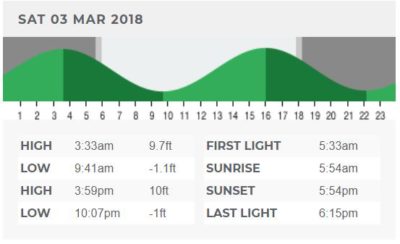
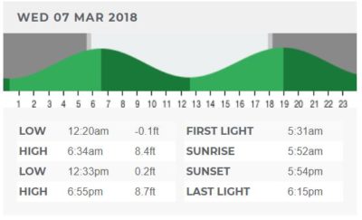
These charts are so easy to read: the peaks are high tide, the valleys are low tide and the white space in the background is sunlight.
With March 3rd our first sunset and March 7th our last sunset, you can see that sunset each day pretty closely correlated with a high tide. Since Tamarindo gets about 12 hours of sun per day, year round, due to its proximity to the equator, generally, the tide condition at sunset is the same condition you’ll get at sunrise. Therefore, high tide sunset will make for a high tide sunrise.
Therefore, my advise to my future self for Tamarindo trip planning, and for you as well if your beach enjoyment is mostly centered around enjoying the beach at sunset, is to plan your trip around the low tide, and thankfully, Magic Seaweed couldn’t make it any easier to do the analysis!
NOTE: It seems that Magic Seaweed has introduced a Pro version that provides unlimited access to the tide charts. Without the pro subscription, you can only access the prior 7 days and following 7 days. While useful for just prior or during your trip, if you are trying to plan for a future trip, you’ll need to use a traditional tide map site. Most tide chart sites are challenging because either they only show current week information, or don’t have the breadth of data to include Tamarindo. The site I found that does the trick is Tamarindo Tides, although it is a bit funky. Go to their site, then click the Tamarindo Tides arrow toward the left side, which opens a window and allows you to select any month of that year to see sunrise, sunset, low and high tide information for every day of the month.
-
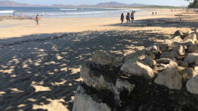
- High tide water almost fills beach
-
- Lower tide, lots of space to find seashells!
Tides for surfing are a different story I’m sure, and one I’ll let others tell you about.
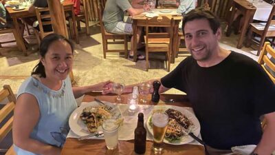 We are Scott and Caroline, 50-somethings who spent the first 20+ years of our adult lives in New York City, working traditional careers and raising 2 kids. We left full-time work in our mid-40’s for location-independent, part-time consulting projects and real estate investing, in order to create a more flexible and travel-centric lifestyle.
  Financial independence and early retirement is not something we originally focused on, but over time realized it was possible. Our free report,